![](/images/other/stat-length.png)
![Randonnée Marche La Frette-sur-Seine - GR2 du port de Cormeilles à Conflans - Photo](https://media.geolcdn.com/t/1900/400/ext.pjpeg?maxdim=2&url=https%3A%2F%2Fstatic1.geolcdn.com%2Fsiteimages%2Fupload%2Ffiles%2F1553511878bg_sport_marche.png)
GR2 du port de Cormeilles à Conflans
sebastienu
Utilisateur
![Longueur](/images/other/stat-length.png)
Longueur
11,1 km
![Altitude max](https://static1.geolcdn.com/siteimages/upload/files/1508320355ic_sort_altitude_max_24dp.png)
Altitude max
72 m
![Dénivelé positif](https://static1.geolcdn.com/siteimages/upload/files/1508320355ic_sort_den_pos_24dp.png)
Dénivelé positif
164 m
![Km-Effort](/images/other/stat-length.png)
Km-Effort
13,3 km
![Altitude min](https://static1.geolcdn.com/siteimages/upload/files/1508320355ic_sort_altitude_min_24dp.png)
Altitude min
13 m
![Dénivelé négatif](https://static1.geolcdn.com/siteimages/upload/files/1508320355ic_sort_den_neg_24dp.png)
Dénivelé négatif
163 m
![Boucle](https://static1.geolcdn.com/siteimages/upload/files/16400158638029165_repeat_loop_refresh_sync_direction_icon.png)
Boucle
Non
Date de création :
2022-04-22 22:16:31.006
Dernière modification :
2022-04-22 22:24:57.858
![Marche](https://static1.geolcdn.com/sitytour/trail-icons/101.png)
3h01
Difficulté : Moyen
![Scannez ce code QR pour ouvrir la randonnée dans l'application SityTrail](https://capi.geolives.com/qq0zvz2zws4bq2lad0pu/sitytour/trails/3214604/qr.png?size=200)
Application GPS de randonnée GRATUITE
À propos
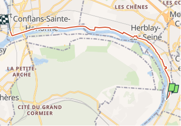
Randonnée Marche de 11,1 km à découvrir à Île-de-France, Val-d'Oise, La Frette-sur-Seine. Cette randonnée est proposée par sebastienu.
Description
Du port de Cormeilles-en-Parisis à Conflans-Sainte-Honorine par le GR2.
Parking sur le centre de vente Bouygues Immo afin d'éviter une section de Sartrouville qui fera sans doute l'objet d'améliorations à l'avenir.
Localisation
Pays :
France
Région :
Île-de-France
Département/Province :
Val-d'Oise
Commune :
La Frette-sur-Seine
Localité :
Unknown
Départ:(Dec)
Départ:(UTM)
440020 ; 5423278 (31U) N.
Commentaires
Randonnées à proximité
![Randonnée Marche Saint-Germain-en-Laye - circuit MA 271019 - Photo](https://media.geolcdn.com/t/375/260/ec0c3cc2-4262-481e-ac4c-e608d5354784.jpg&format=jpg&maxdim=2)
![Marche Marche](https://static1.geolcdn.com/sitytour/trail-icons/101.png)
circuit MA 271019
Marche
Très facile
(1)
Saint-Germain-en-Laye,
Île-de-France,
Yvelines,
France
![](/images/other/stat-length.png)
4,7 km | 5,2 km-effort
1h 3min
![](https://static1.geolcdn.com/siteimages/upload/files/16400158638029165_repeat_loop_refresh_sync_direction_icon.png)
Oui
![Randonnée Marche Maisons-Laffitte - Forêt de Saint Germain en Laye - Photo](https://media.geolcdn.com/t/375/260/ext.jpg?maxdim=2&url=https%3A%2F%2Fservices.sitytrail.com%2FGeolivesWS%2FDownloadMedia.ashx%3FTrailID%3D110160%26Media%3D5360_1.jpg)
![Marche Marche](https://static1.geolcdn.com/sitytour/trail-icons/101.png)
Forêt de Saint Germain en Laye
Marche
Difficile
(2)
Maisons-Laffitte,
Île-de-France,
Yvelines,
France
![](/images/other/stat-length.png)
22 km | 25 km-effort
4h 30min
![](https://static1.geolcdn.com/siteimages/upload/files/16400158638029165_repeat_loop_refresh_sync_direction_icon.png)
Oui
![Randonnée Marche Le Mesnil-le-Roi - RS 5 km porte chene corbeau - Photo](https://media.geolcdn.com/t/375/260/ext.jpg?maxdim=2&url=https%3A%2F%2Fstatic1.geolcdn.com%2Fsiteimages%2Fupload%2Ffiles%2F1553511878bg_sport_marche.png)
![Marche Marche](https://static1.geolcdn.com/sitytour/trail-icons/101.png)
RS 5 km porte chene corbeau
Marche
Facile
(1)
Le Mesnil-le-Roi,
Île-de-France,
Yvelines,
France
![](/images/other/stat-length.png)
5,2 km | 5,8 km-effort
1h 18min
![](https://static1.geolcdn.com/siteimages/upload/files/16400158638029165_repeat_loop_refresh_sync_direction_icon.png)
Oui
![Randonnée Marche Saint-Germain-en-Laye - 20230824 5S 5KM - Photo](https://media.geolcdn.com/t/375/260/ext.jpg?maxdim=2&url=https%3A%2F%2Fstatic1.geolcdn.com%2Fsiteimages%2Fupload%2Ffiles%2F1553511878bg_sport_marche.png)
![Marche Marche](https://static1.geolcdn.com/sitytour/trail-icons/101.png)
20230824 5S 5KM
Marche
Moyen
(1)
Saint-Germain-en-Laye,
Île-de-France,
Yvelines,
France
![](/images/other/stat-length.png)
5,5 km | 6,3 km-effort
1h 25min
![](https://static1.geolcdn.com/siteimages/upload/files/16400158638029165_repeat_loop_refresh_sync_direction_icon.png)
Oui
![Randonnée Marche Saint-Germain-en-Laye - MBE 5 km le mesnil route des portes - Photo](https://media.geolcdn.com/t/375/260/ext.jpg?maxdim=2&url=https%3A%2F%2Fstatic1.geolcdn.com%2Fsiteimages%2Fupload%2Ffiles%2F1553511878bg_sport_marche.png)
![Marche Marche](https://static1.geolcdn.com/sitytour/trail-icons/101.png)
MBE 5 km le mesnil route des portes
Marche
Facile
(1)
Saint-Germain-en-Laye,
Île-de-France,
Yvelines,
France
![](/images/other/stat-length.png)
4,8 km | 5,3 km-effort
1h 11min
![](https://static1.geolcdn.com/siteimages/upload/files/16400158638029165_repeat_loop_refresh_sync_direction_icon.png)
Oui
![Randonnée Marche Maisons-Laffitte - 20220909 RS - Photo](https://media.geolcdn.com/t/375/260/ext.jpg?maxdim=2&url=https%3A%2F%2Fstatic1.geolcdn.com%2Fsiteimages%2Fupload%2Ffiles%2F1553511878bg_sport_marche.png)
![Marche Marche](https://static1.geolcdn.com/sitytour/trail-icons/101.png)
20220909 RS
Marche
Moyen
(1)
Maisons-Laffitte,
Île-de-France,
Yvelines,
France
![](/images/other/stat-length.png)
5,7 km | 6,4 km-effort
1h 26min
![](https://static1.geolcdn.com/siteimages/upload/files/16400158638029165_repeat_loop_refresh_sync_direction_icon.png)
Oui
![Randonnée Marche Saint-Germain-en-Laye - 20220220 Petite boucle en forêt de Sy Germain - Photo](https://media.geolcdn.com/t/375/260/ext.jpg?maxdim=2&url=https%3A%2F%2Fstatic1.geolcdn.com%2Fsiteimages%2Fupload%2Ffiles%2F1553511878bg_sport_marche.png)
![Marche Marche](https://static1.geolcdn.com/sitytour/trail-icons/101.png)
20220220 Petite boucle en forêt de Sy Germain
Marche
Facile
(1)
Saint-Germain-en-Laye,
Île-de-France,
Yvelines,
France
![](/images/other/stat-length.png)
8,2 km | 9,2 km-effort
50min
![](https://static1.geolcdn.com/siteimages/upload/files/16400158638029165_repeat_loop_refresh_sync_direction_icon.png)
Oui
![Randonnée Marche Saint-Germain-en-Laye - Circuit MA 151219 - Photo](https://media.geolcdn.com/t/375/260/569e8f34-02aa-4776-807c-cdcab1bc2616.jpg&format=jpg&maxdim=2)
![Marche Marche](https://static1.geolcdn.com/sitytour/trail-icons/101.png)
Circuit MA 151219
Marche
Très facile
(1)
Saint-Germain-en-Laye,
Île-de-France,
Yvelines,
France
![](/images/other/stat-length.png)
6,7 km | 7,5 km-effort
1h 26min
![](https://static1.geolcdn.com/siteimages/upload/files/16400158638029165_repeat_loop_refresh_sync_direction_icon.png)
Oui
![Randonnée Marche nordique Saint-Germain-en-Laye - SityTrail - MN CDN 14 KM MARE AUX CANES - Photo](https://media.geolcdn.com/t/375/260/ext.jpg?maxdim=2&url=https%3A%2F%2Fstatic1.geolcdn.com%2Fsiteimages%2Fupload%2Ffiles%2F1545311037marcheuse_200dpi.jpg)
![Marche nordique Marche nordique](https://static1.geolcdn.com/sitytour/trail-icons/102.png)
SityTrail - MN CDN 14 KM MARE AUX CANES
Marche nordique
Très facile
(1)
Saint-Germain-en-Laye,
Île-de-France,
Yvelines,
France
![](/images/other/stat-length.png)
13,9 km | 15,6 km-effort
2h 0min
![](https://static1.geolcdn.com/siteimages/upload/files/16400158638029165_repeat_loop_refresh_sync_direction_icon.png)
Non